by Steve Tanham

photo taken in summer)
Our small village, Sedgwick, near Kendal, has a landscape shaped in the classic terminal topography of ancient glaciers. This area of gentle, rounded hills is typical of the final stages of the glacier’s course. The English Lake District, where we live, has them in abundance. ‘Basket of Eggs’ is another term you may remember from those geography text books at school. They are also known as ‘drumlins’.

These small hills get bigger as you journey nearer to the centre of the region. The northern half of Lake Windermere was formed from a glacier whose origin was the mountain of Fairfield, a few miles north of Ambleside, at the head of the lake. See picture, above.
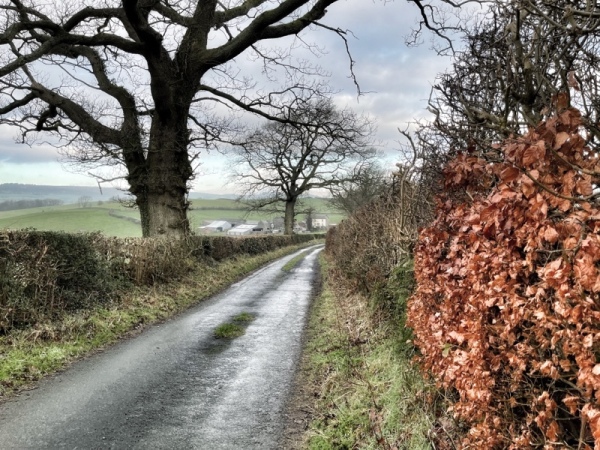
It’s the Friday before the third Sunday in the month. You’ll find me with a very happy Collie dog – Tess, walking from Sedgwick along the quietest country lanes and tracks towards the hill you can see in the distance in the opening photo – The Helm (also spelled Helme). It doesn’t look too far in that shot, but it’s a three mile walk, and takes about ninety minutes at a fast walking pace.
I love walking. You couldn’t live here and not do. But there’s a practical side to this monthly outing. I’m meeting up with Stuart France, my co-director of the Silent Eye… and we’re planning on having a couple of beers, whilst mapping out the next month of activities – including our new monthly Zoom chat – open to anyone interested.
That’s right – it’s a board meeting! But one held in a station… which may sound odd, but all will be revealed…
A year ago, Sue Vincent – as the third Director of the School, would have been part of the group meeting. This would have taken place in the distant hills of Derbyshire – the place where we’ve regularly held our Spring workshops.
Sadly, as many readers will know, Sue passed away last Spring, leaving the two of us to sail the Silent Eye ship. We are not alone, though, and have a great team of people to assist us – for everything from healing groups to highly-skilled administrative and document production assistance.
Technically, Stuart and I are ‘retired’…but you wouldn’t know it from our average working week of writing, teaching and lesson supervision.
Stuart used to live in Sheffield, which was an ideal base for our monthly meetings in the hills of Derbyshire. After Sue’s passing, Stuart decided to relocate back to his native Lancashire. This was to our mutual advantage because there is a fast rail connection between Preston and the place I’m headed – Oxenholme; the only mainline station in the UK located in a village. Quizzers take note. This might win you a prize!

My journey takes me from our house near the centre of Sedgwick, along a steep country lane that runs beneath the West Coast Main Line. We’ll meet this vital link between London and Scotland, again, later. The bridge and line are only ten minutes from the house. If the wind is in the right direction, you can just about hear the trains at night as they thunder northwards to and from Glasgow and Edinburgh. There’s something magical about it…
The road crests a hill then descends to the village of Crosscrake, where we take a tiny lane up the first of several steep ‘drumlin’ hills. These are lined with dense hedges, most of which have just been trimmed. The resulting sharp relief is a pattern to be exploited by the photographer.

Frustratingly, the lane then plunges down the hill to climb all the way up again – an unavoidable property of the egg ‘basket’ hills. This one is very steep. But, ten minutes later, and somewhat hotter, we’re at the top.
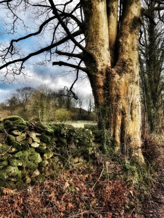
Soon, we pass one of my favourite gardens, with its oak tree set just off the entrance drive. The photo was taken in October, and the autumn colours allowed me to indulge in a little fine-tuning.

The country lane marks the end of the ancient drumlin and leads to a minor junction of the celebrated A65 – the old trunk road that links Kendal to Skipton – and beyond to York and the East Coast.
There is always beauty to be found in the hedgerows, even on the busy A65. This image was taken here in October…

Beyond the major road the way begins to climb up the initial slopes of The Helm, but the trees are so dense you can’t see the large hill looming above.
We now have a choice… We can continue along the narrow lane and skirt the base of The Helm… or, with the Collie expressing a strong preference, we can set off on a rapid and lung-challenging ascent of the steepest face of the hill.

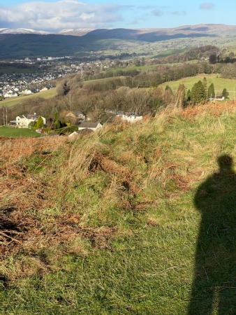
If we are feeling fit – and the Collie insists – we arrive, breathless at the summit of The Helm, fifteen minutes later. It’s a steep but rapid scramble to the ‘trig point’, but the views are worth it. Kendal is laid out below us like a street map, with the West Coast Main Line skirting the base of The Helm. The air is always pure… and often freezing!


Tess loves being here because it’s where we often come (by car) to ‘chuck the frisbee’. Today, however, her fun is curtailed by the sound of shotguns in the next valley. She scampers around, tail down and frightened. Collies are very sensitive creatures…
We’ve done all we can up here. The Collie’s walk will have to be sufficient. Now it’s time to descend to the edge of the village of Oxenholme, where Stuart will be arriving by train in the next 30 minutes.
The Helm is topped by a beautiful, long ridge. We can follow this all the way down to the road that leads into Oxenholme Station.


Stuart arrives on-time from Preston. We’re now going to leave one station to have our ‘board meeting’ in another – and its not the one in Kendal.

Fifteen minutes later, two human and a Collie are ready to have their meeting…

And that’s the end of the journey…. Except if we decide to walk home at the end of our chat. The alternative is to ring Bernie, who will gladly drive the fifteen minutes to collect me, while Stuart strolls down to the station to catch his train.
But the thought of walking home through that beautiful coming sunset and the photographs it might offer is calling… But we’ll not be going over The Helm!

©Stephen Tanham 2022
Stephen Tanham is a Director of the Silent Eye, a journey through the forest of personality to the dawn of Being.
http://www.thesilenteye.co.uk and http://www.suningemini.blog


")


Enchanting , Thankyou
LikeLiked by 1 person
My pleasure. Giselle. Glad you liked it 😃
LikeLike
What a beautiful part of England…:) x
LikeLiked by 1 person
Thank you. It is… but the winters are wet and muddy! ♥️
LikeLiked by 1 person
As they are in many places Steve its part of the territory for winter.. ❤️
LikeLiked by 1 person
Ah Steven, beautiful. I visited a bit of that district a few years ago and the beauty of it stays in my heart!
LikeLiked by 1 person
Thanks, Chris. We are blessed – but it was decades in the making. Mind you, when we’re ankle-deep in mud, I do wonder….!
LikeLiked by 1 person
Lovely photos, Steve. I am yearning to return to the Lakes! Thank you for giving me this opportunity.
LikeLiked by 1 person
Glad you enjoyed it, Caroline 😊
LikeLike